
Catalan Atlas: Portolan Meets Mappa Mundi
20
Jun
Referred to as one of the last great mappa mundis before the emergence of ptolemic maps in the 15th century, the Catalan Atlas was produced in 1375, with the originals in the Bibliothèque Nationale de France (National Library of France) in Paris today. The creator of the Catalan Atlas is believed to be the Majorcan Jew, Abraham Cresques, and was given as a gift to Charles V of France. Combining geography, peoples, cosmography, navigation, astronomy, astrology, and planetary information, the Catalan Atlas was viewed as representative of the most complete illustration of geographical knowledge at the time.
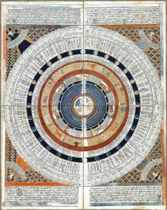
Calendar Wheel with Earth at Center and Text Written in Catalan Language: George Glazer Gallery
The Catalan Atlas is a multi-sheet world map on six vellum sheets. The map’s orientation is from left to right, from the Far East to the Atlantic, and is read with the north at the bottom. It was created from a few different sources including the typical circular mappa mundi of medieval times, the portolan coastlines of the Mediterranean and Black Sea, and Western Europe, as well as features drawn from the accounts of 13th and 14th century travelers to Asia. The first two sheets contain illustrations and texts highlighting elements of cosmography, astronomy, and astrology in Catalan language. The earth is presented as a spherical shape, and a diagram conveying useful information pertaining to tides and nocturnal time keeping that was useful to sailors is depicted. The additional sheets make up the actual map, which shows illustrations of various cities that can partly be identified by a flag. A cross or dome indicates a Christian city, while oceans are
No comments yet.