
Derrotero Mission Map from Monterrey to Santa Fe
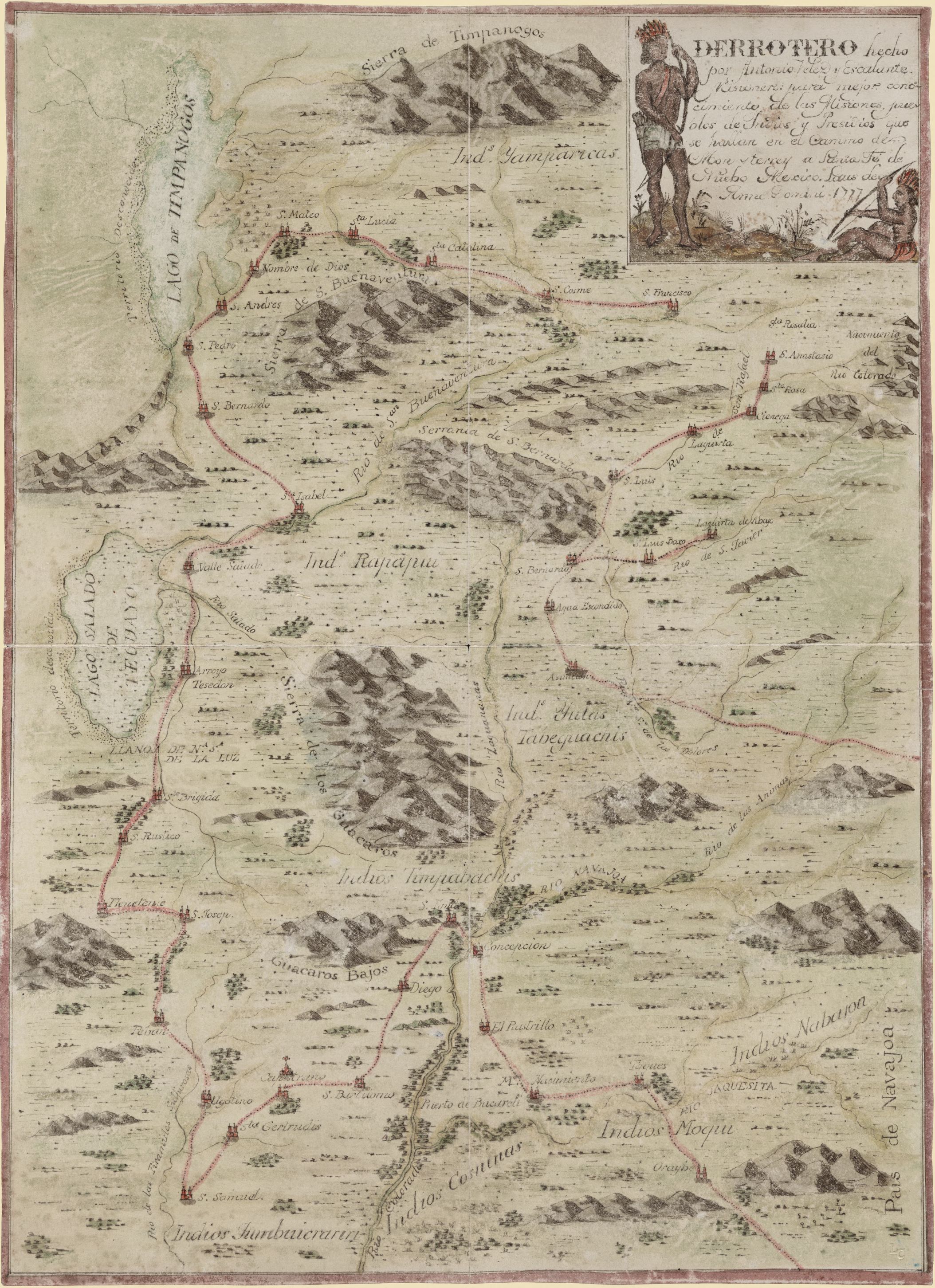
Derrotero hecho por Antonia Vélez y Escalante….en el Camino de Monterrey a Santa Fe de Nuebo Mexico.
As I was going through some southwest maps recently I came across this map. As a map artist I am most attracted to maps that tell a story. I instantly fell in love with the little characters at the top and the primitive typography.
In the early days of exploration, little was known about new territories in the west. However, we can credit the Spanish for enlightening us on the location of towns and indian tribes scattered across the rugged wilderness. As they made their way across the New World, maps came to life, showing much more than basic topography. Take this 1777 map by Derrotero for instance. The translation of the title title is “The route map made by Antonio Velez y Escalante missionary for improved knowledge of the missions, Indian Pueblos, and towns found on the road from Monterey to Santa Fe in New Mexico”.
Portions of Colorado, Arizona, and Utah are included in the map. Escalante’s journey gave greater insight into what was going on in the area at the time, by giving a more defined understanding of towns and missions found along the route. The group he set out with was unable to complete the journey and had to return, however, we are left with a pretty stunning display of details, for the portions of the road they traveled.
Of noteworthy mention are two lakes in the upper left-hand corner. These are more than likely what we know as the Great Salt Lake and Utah Lake. They are labeled Lagos de Timpanagos and Lago Salado de Teguayo. Also, pay close attention to the routes pictured in red. These are the routes that Escalante traveled with his group during their charting expedition. They contain the locations of various Native American tribes as well as a handful of missions that are peppered along the way. This was helpful for future explorers and for those looking to establish trade with local populations of Native Americans should they be open to it. Finally, look at the bottom of the map and you will see the Rio Colorado, otherwise known as the Colorado River.
The topography is expertly detailed, and the hand coloring as a bit of drama to a map that otherwise would be rather plain. No state boundaries are pictured on the map as it would be many years before they were defined. Territories were the order of the day and exploration was the way to stake your claim. A great look at history and exploration by the Spanish, Derrotero’s map is a great representation of early Spanish cartography. Attention was paid to location rather than topographic detail. It is apparent by looking at the map that the goal was to inform people about the area rather than present them with a beautiful picture of the same.
In the end this would prove most valuable to settlers and adventure seekers. Maps with town and tribal information would let them know which places were friendly and which would be best avoided. As settlements grew, so would the detail of the maps. Railway lines and trade posts would later find their place, as would state boundaries and government. Yet here we see map making in its most base form…through a Spanish explorer charting unknown territory.
©2015 Great River Arts All Rights Reserved
One Response to “Derrotero Mission Map from Monterrey to Santa Fe”