
Hiberniae Britannicae
 This Abraham Ortelius map, Hiberniae, Britannicae Insvlae Nova Descripto, is an early map of Ireland published in 1598. It was first published in 1573 and is compiled from Gerardus Mercator’s 1564 map depicting the British Isles, which greatly improved the accuracy and outdoing his previous representations. The map was part of Ortelius’s landmark 1598 atlas. Do you know who is considered the inventor of the modern atlas? That would be no other than Abraham Ortelius himself.
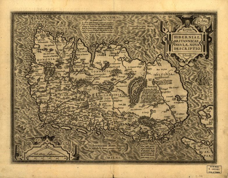
Ortelius was a Flemish engraver and a prominent mapmaker, perhaps the most popular and frequently collected of the mapmakers of his time. His atlas Theatrum Orbis Terrarum (Theater of the world) was published in Antwerp in 1570 and presented the world in a way that showed the influence of the period of exploration, growing commercial links, and advancements in scientific inquiry. Ortelius’ Theatrum Orbis Terrarum is largely said to be the world’s first atlas. As time went by, the original atlas was updated often and its accuracy enhanced based on the newest scientific and geographical knowledge.
Ortelius’ Hiberniae, Britannicae Insvlae Nova Descripto reflects the latest enhancement in modern mapmaking techniques of the early 16th century. What did these techniques include? Accurate geographic detail, nicely drawn topographical symbols, and plenty of place names helped in making Ortelius’ maps the most precise and accurate representations at the time. This helped to make him a standout mapmaker of his era.
Ortelius’s map of Ireland, Hiberniae, Britannicae Insulae Nova Descriptio translates A new depiction of Ireland, a British Isle. The map’s detailed text is in Latin. Notable highlights include mention of Queen Elizabeth I of England, who was also Ireland’s Queen, and quotes shown pulled from the voices of people like Lacus Erno (Lough Erne), the scholar Gyraldus Cambrensis (Gerald of Wales), and Saint Patrick’s Purgatory. Relief is shown pictorially, a scale is situated in the lower-left corner of the map, while west (occidens) is at the top, north(septentrio) is to the right, east (oriens) at the bottom, and south(meridies) to the left. Several sailing ships are also depicted, perhaps a representation of the exploration that was taking place.
The purpose of this map may have been to educate, building on previous geographical knowledge, and making improvements that enhanced Ortelius’ atlas. As a scholarly tool, Britannicae Insvlae Nova Descripto was also a reference for other cartographers to pull information from to draw maps of their own later on. This map became part of a great body of work that is notable today in the world of cartography.
No comments yet.