
Travel Tuesday Map Series: 010 A new map of Lake Pepin 2014 By Lisa Middleton
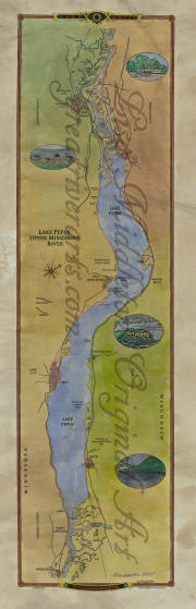
This beautiful 2014 historical and geographical map of Lake Pepin on the Mississippi River was created by Midwestern Map Artist, Lisa R. Middleton from current U.S. Army Corps of Engineer Charts. It pinpoints numerous islands and landmarks visible to those cruising on land or on water. The Sea Wing, traveling between Lake City and Stockholm, overturned during a storm in 1890, killing some 98 passengers and crew in the Lake Pepin’s worst disaster.
The place names on Lake Pepin have particular historical significance. Some, like Stockholm or Reads Landing, commemorate the immigrants from Europe who settled the upper Mississippi River. Red Wing and Wabasha along the Minnesota shore reference several generations of Dakota Sioux chieftains. The surnames Pepin and Frontenac, and the French forts of St. Beauharnois and St. Antoine date back to the first French explorers in the middle of the 17th and early 18th centuries.
Lake (Lac) Pepin first appeared on a map of New France by Guillaume de L’Isle in perhaps 1720, to immortalize Etien Pepin who had received a huge French land grant in the area. Frontenac was the name of the French Colonial Governor of Canada for many years, between 1672 and 1698. The Ursuline order of nuns who first arrived in the infant New Orleans in 1727, also established a presence in association with missionaries at Fort St. Beauharnois (1727).The order continues to operate Villa Maria Conference and Retreat Center on the site.
*watermark will not appear on your purchase
All Sizes are approximate.
No comments yet.