
Old Map Studies: Myths and Legends of the Ancient Mississippi River Valley as Told Through Maps!
Myths and Legends of the Ancient Mississippi River Valley as Told Through Maps
The Mississippi River Valley, running from the present-day U.S. states of Illinois, Missouri, Arkansas, Louisiana and Mississippi, has been riddled with myths and legends, regarding the settlement, cultural influence and establishment of North American pre-Columbian civilization and what we now accept as history of Native American tribal ancestry. The River’s rich resources would, in the ancient past, and the future, provide for the rich success of maritime commerce. Mankind’s attempts to know it, tame it, and document it, have left behind a treasure trove of myths and attempts to explain the possibility that other expedition adventures were made to the Americas. Here, we will consider the Mississippi River Valley myths authored today, and spread by unreliable sources in the field of map-making, as well as the questions that remain debated among scholars.
“The late James H. Campbell who worked in his youth with Thomas A. Edison, said that once, when a difficult problem was being discussed, Edison said it was too difficult for any specialist. It would be necessary, he said, to wait for some amateur to solve it.”
When we consider our present-day world, that imperfect man, who tends to lean toward a natural bias, often closes his mind to anything other than the respected source he learned from, whether it is religious, secular, or otherwise, we remember that an intelligent mind understands that passion for a subject can spark a curious quest for answers. When that curiosity is sparked, we all must begin from somewhere. Having said that, it is not unimaginable for any amateur to contribute, what might in the future be accepted as fact. Consider, that the classical age allowed for opinions and philosophies about the earth and universe, even though religious opposition was present. The Renaissance followed. During this Renaissance period, (the literal definition meaning: “New Birth”), when philosophers and scientists, Ptolemaios, and Eratosthenes claimed the world was a sphere, medieval mainstream sciences dismissed it as nonsense. Today mainstream science accepts this as fact.
In just the last hundred years of human history, we have witnessed new disciplines which create new ways to examine the past. “Demography, climatology, epidemiology, economics, botany, palynolgy (pollen testing), biology, carbon-14 dating, ice-core sampling, satellite photography, soil assays, genetic […] analysis” allowed for a very long list of new theories, based on the mountain of new results and possible angles for scientists to consider. Just imagine- this new information, has made it close to impossible for scholars to reach any agreements on the old theory that the globe had changed little for thousands of years prior to European exploration. It is safe to say, at this point, that this was quite unlikely. It also allows us to come up with some very colorful stories of adventure!
We must recognize, that the Spanish fleet led by Christopher Columbus was not the only, nor the first, seafaring population capable of reaching, and discovering the “new world.” Archaeological evidence, of the seafaring capabilities, of the Mongols, and Chinese, Minoans, Sumerians, and Phoenicians, of the Mediterranean, Egyptians of the Fertile Crescent, the Arabs, the Norse of Scandinavia, and the Celts, supports the fact that these people possessed more methods of taming the seas through intelligent design, and engineering, than previously accepted or discovered.
However, the long list of evidence provided to prove this, has opened a doorway to speculation of the widest variety. Simply put, these theories, and sometimes myths, are that each of the above civilizations, did arrive in the Americas before Christopher Columbus explored the continent, and most theories center around the Mississippi River Valley. Most theories about earlier exploration around the Mississippi River involve three things. First, there is the historical claim by these cultures to have long traveled the seas towards Western lands from Eastern Asiatic lands, and this will explain the long-argued controversies over maps made by them. Secondly, alleged evidence claims to support these hypotheses- some are frauds, and some are accepted as fact, by mainstream scholars, which still cannot currently be explained. We must also consider that exploration is often sought after by humans when trying to achieve an understanding of the exotic and unknown. This alone, is enough motivation for any civilization to set out to discover uncharted lands.
Myths and legends have been written about whether the Mayans or Egyptians reached the Mississippi River Valley. Barry Fell, a Harvard Marine Biologist, considered a fringe historian, perpetuated a myth that, based on alleged similarities between Micmac and Algonquin temples and effigy worship mounds, compared with Egyptian pyramid builds, that this proves contact must have been made about 800 B.C. between the two worlds. In his book entitled America B.C.: Ancient Settlers in the New World, he goes to great lengths to chart similarities between the Zuni tribal language and Libyan or Middle Egyptian. He also drew similarities between the Micmac tribal carvings and, Egyptian hieroglyphs, while setting out to argue the Asiatic origins of Amerindian languages. Ancient Mississippian civilization is said to have used the same advanced agricultural skills that the Mesoamericans used, in particular the Mayans. Post-Columbian French explorers, later found the Natchez natives with a caste system, similar to the Mayans. Also found among these early people, were sun worship, monuments built over their dead, and ritual human sacrifice. The single, most striking argument for the Egyptians having reached there, involved the ancient burial mounds, some said to be bigger than the Great Pyramids of Egypt. Questions being asked were, whether the Egyptians influenced the Mayan civilization, because Mayan Ziggurats are also strikingly similar in nature to the pyramids. And while Fell may have drawn a following, because many have long thought that Amerindians originated from Asiatic peoples crossing over Bering Strait, there is no current acceptance of his theories among mainstream sciences. One should also consider the fact that Ziggurats, otherwise known as pyramids, are found on nearly every continent on the globe, in some form.
The Chinese are also theorized to have arrived in the Mississippi Valley. Questions that remain puzzling are the evidences that cannot be disproven- current genetic DNA testing done among Native American tribes. These studies have shown striking, and unmistakable genealogy between Chinese genes and those of Native Americans. Even still, scholars disagree on the idea of the Chinese reaching North America. So, could the Chinese have arrived before Columbus? All contact theories of the Chinese arriving in the Americas, usually involve Central or South America. However, in his book Who Discovered America, Gavin Menzies listed a study conducted by the Mormons (who house the one of the largest genealogy databases in the world) published in 2006, named Losing a Lost Tribe: Native Americans, DNA, and the Mormon Church. In his book, he states: “more than seven thousand DNA samples were procured, from 175 recognized indigenous Native American peoples. The results showed 96.5 percent of indigenous Native American people had mitochondrial DNA from A, B, C, and D founding maternal lineages. Remarkably, those four DNA lineages are found only in Asian populations and nowhere else in the world.”Menzies then perpetuated the theory that Zheng He traveled to the Americas in 1421.12. In Figure 1, The Zheng He Map clearly shows both the Eastern and Western continents of the globe and was promoted by Menzies, however it was “discovered” conveniently after publishing his work and promoted perhaps to prove his theory. The map has been considered a manufactured imitation of those of the European tradition- because it is a spherical rendition of the globe. In his section concerning Pyramids in Mexico and Central America he claims that “Monte Alban is a half-scale copy of [the Chinese] Emperor Qin’s mausoleum.”
Legends of the Arabs reaching the New world in the eight century A.D. are told by the Arabs themselves. Piri Re’is, an admiral and conqueror for the Ottoman Empire, drafted his own map of the Western Atlantic (See Figure 4). And while claiming his original source for some of its geographical details were from a map drawn by Columbus himself, Piri Re’is makes a mockery of the Spaniards enlisting Columbus for a voyage, he says was already achieved long before Europeans. Admiral Re’is is quoted as saying “These coasts are named the shores of Antilia. They were discovered in the year 896 of the Arab calendar. But it is reported thus, that a Genoese infidel, his name was Colombo, he it was who discovered these places.” The map itself is agreed by scholars to be correctly dated. However, Piri Re’is sources are debated. Most puzzling is that Captain Arlington H. Mallery “suggested that the Piri Re’is Map […] showed a part of Antarctica.” Our current understanding of Antarctica doesn’t allow for its discovery and exploration until centuries later. Could this admiral have retrieved this information relevant to Columbus’ travels from a map that has never been found- “the missing map of Columbus?”
Leif Erikson, is said to have made regular expeditions, along with other Vikings, to what we now consider Greenland or Newfoundland around 875 A.D. This land mass was not known by the map makers of Southern Europe until Claudius Clavus paid visit to Italy. It is said to have been mentioned by just two non-Scandinavian writers prior to Columbus’ voyage, those being Adam of Bremen (c. 1070) and Ordericus Vitalis (c. 1140).In his book, The Vinland Map and The Tartar Relation, Skelton seems to make it apparent, that it is commonly accepted by present day scholars that “In the Vinland Map [… See Figure 3] we see the only known cartographic delineation of American lands before the discoveries of Columbus and Cabot.” Note the map’s recognition of land mass into the Atlantic. These were uncharted waters to the Europeans during the Viking age. Skelton claims: “It is neither depicted nor named in any medieval map so far known.” And so, we are faced with another example of the possibility of travel by another civilization outside the traditional notion that Western Europeans had first claim to a so-called discovery these lands. Instead, it seems, a civilized culture was already found to exist.
So then is the myth really after all, the teaching that Columbus Discovered America? Though there are many unexplained mysteries and questions unanswered, the world according to ancient maps was an earth radically different than the one we know now, and still, uncovered archaeology supports these theories concerning pre-Columbian exploration. Consider the overwhelming common factor of those earlier mentioned- the Mississippi River Valley. What if it were true? We should consider that the later maps referenced here do prove that these early explorations were possible, and we should ask questions such as, why are theories things that are always so ever-changing? Does this occur because, as we considered in the beginning of this article, they don’t fit the present pattern of thought? Or is it because as science advances for the human race, less is left to interpretation? Why then, when there are evidences accepted as fact, do these matters not lead to any agreement between scholars? Do we responsibly question everything, and recognize the difference between dishonest and unreliable sources from provable facts? And, lastly, what will the future of cartography involve?
Examples of proposed early exploration to the Americas include Figures 1 (Zheng He Map) and 4 (Piri Re’is Map). Chinese, European, Scandinavian and Arab alike have claimed an early presence in the Western Hemisphere. Many today are still unauthenticated, and are not considered among mainstream scholars to hold veritable truths. Others are authenticated and yet consensus cannot be reached as to their origin.
Figure 1. The Chinese
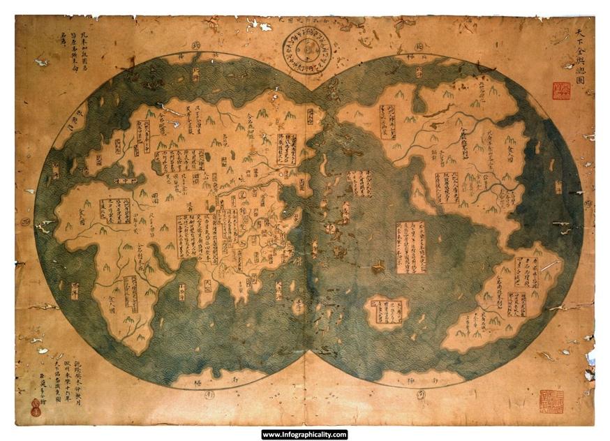
The Zheng He Map (c. 1421)
Much effort has gone into discrediting this map as it does not coincide with Mongolian tradition, but instead with European dual hemisphere maps. It is also questionable since, China did not include itself as the center of the map. For these reasons it is proposed as an elaborate hoax of an unreliable source. Compare with Figure 2.
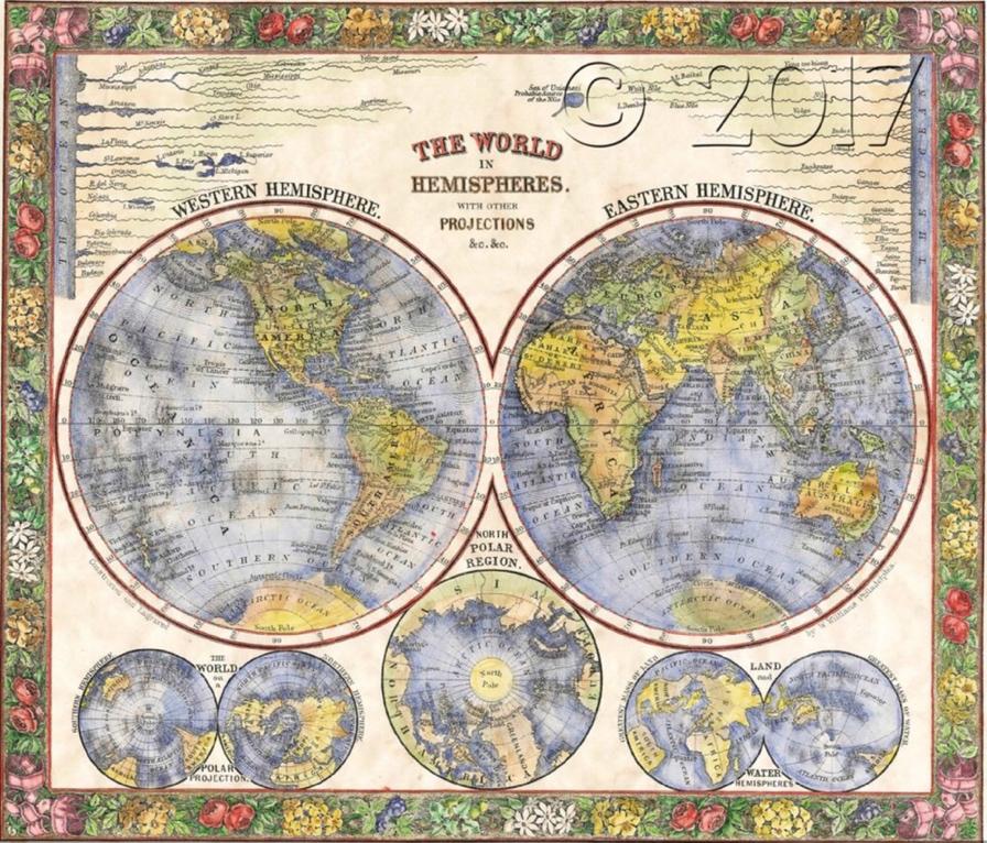
Figure 2. European
S. Augustus Mitchell Jr.’s World Map (c. 1864) Buy here!
Here is an example of a dual hemisphere map, of the European cartography tradition, of which the Zheng He map is said to imitate. It is pre-Mercatorial, meaning a meridian line is not used to alter the spherical nature of the map.
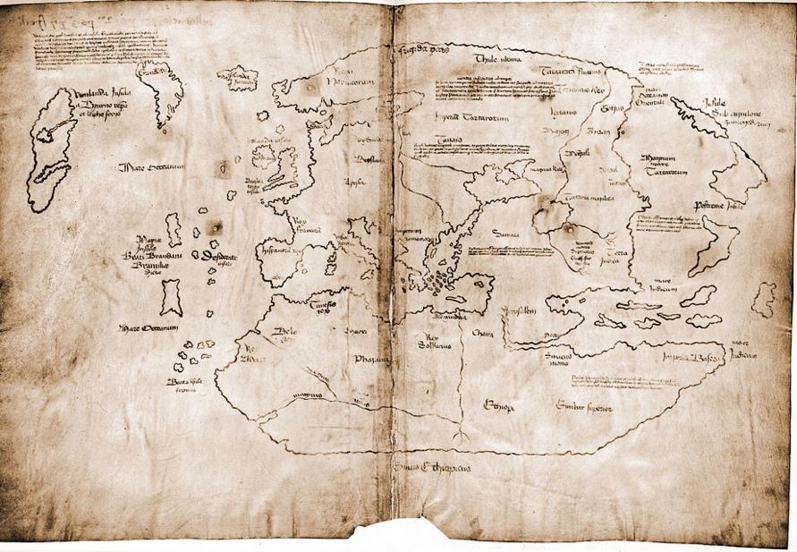
Figure 3. The Norse Vikings of Scandinavia
The Vinland Map (c. 1440)
Leif Erikson documented travels to Greenland (Newfoundland) prior to Columbus. Some consider it to be the only documented proof of pre-Columbian exploration to the American continents.
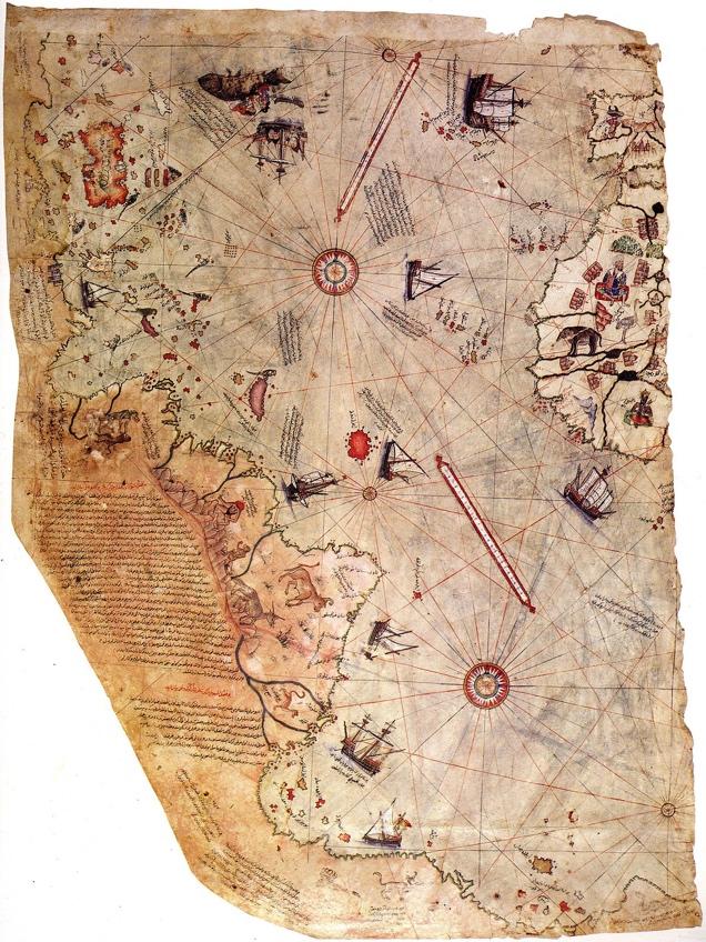
Figure 4. Arabs and The Ottoman Empire
Piri Re’is (Admiral) Map (c. 1513)
Here, the Turkish admiral, refers to Christopher Columbus “the infidel,” and attests to the Arabs having reached the Americas prior to the Spanish Queen. Albeit, he credits some of his references to a map still unaccounted for and drafted by Columbus. It is agreed by scholars to be authentically drawn and accurate as to date. However, the sources Piri Re’is drew from are in question.
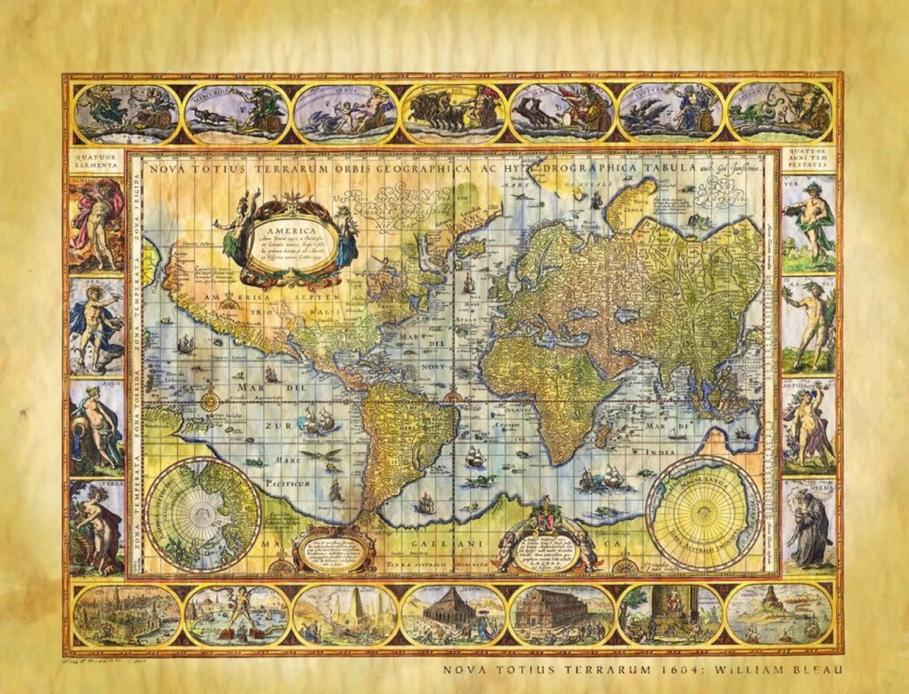
Figure 5. Willem Blaeu’s Nova Totius Terrarum Orbis Geographica ac Hydrographica Tabula (circa 1694). Buy Here!
An example of the mercatorial projection in use.
Works Cited
-
Hapgood, Charles H., Maps of the Ancient Sea Kings: Evidence of Advanced Civilization in the Ice Age, (Souvenir, 2001), 3, footnote
-
Afetinan, A, Life and Works of Piri Reis: the Oldest Map of America, (Turkish Historical Society, 2008), 7, par. 1
-
Mann, Charles C, 1491: New Revelations of the Americas before Columbus, (Knopf, 2012), 15, par. 2
-
Golay, Michael, and John Stewart Bowman. North American Exploration, 18, par. 1
-
Fell, Barry, America B.C.: Ancient Settlers in the New World, (Hoffman Printing, 2012), 175, par. 3
-
Fell, Barry, America B.C.: Ancient Settlers in the New World, 257, par. 1
-
Fell, Barry, America B.C.: Ancient Settlers in the New World, 7, par. 1, 17, par. 2
-
Henretta, James A., et al, America: a Concise History, (Bedford/St. Martin’s, 2010), 12, par. 3
-
Henretta, James A., et al, America: a Concise History, 13, par. 2
-
Menzies, Gavin, and Ian Hudson, Who Discovered America?: the Untold History of the Peopling of the Americas, (William Morrow, an Imprint of HarperCollins Publishers, 2014), 65, par. 1
-
Menzies, Gavin, and Ian Hudson, Who Discovered America?: the Untold History of the Peopling of the Americas, 65, par. 3
-
Menzies, Gavin, and Ian Hudson, Who Discovered America?: the Untold History of the Peopling of the Americas, 66, par. 4
-
Menzies, Gavin, and Ian Hudson, Who Discovered America?: the Untold History of the Peopling of the Americas, 119, par. 1
-
Afetinan, A, Life and Works of Piri Reis: the Oldest Map of America, 30, par. 3
-
Hapgood, Charles H., Preface to Maps of the Ancient Sea Kings: Evidence of Advanced Civilization in the Ice Age
-
Skelton, Raleigh Ashlin., et al, The Vinland Map and the Tartar Relation, (Yale Univ. Press, 1995), 233, par. 1
-
Skelton, Raleigh Ashlin., et al, The Vinland Map and the Tartar Relation, 233, par. 1
-
Skelton, Raleigh Ashlin., et al, The Vinland Map and the Tartar Relation, 233, par. 2
-
Skelton, Raleigh Ashlin., et al, The Vinland Map and the Tartar Relation, 233, par.1
No comments yet.