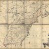
The Mitchell Map, or Map of the British and French Dominions in North America, believed to have been created in 1754 or 1755, is the work of John Mitchell, who came from a wealthy Virginian family. He was not a professional cartographer by trade, and his formal education was in medicine and botany. His map was […]


Follow Us!