
Discovery Map Series: The Lost Map of Joliet
The story told is that upon returning to Montreal, Canada, following his exploration of the Great Lakes and the Mississippi River 1673-1674, with Jesuit missionary Jacques Marquette, Louis Joliet, at the request of French officials, drew from memory the “Nouvelle decouverte de plusieurs nations dans la Nouvelle France en l’année 1673 et 1674”, translated “New Discovery of Several Nations in New France in the Years 1673 and 1674.” Joliet lost all of his records of his exploration when his boat capsized in the St. Lawrence River. Louis Joliet was a Canadian explorer, who, despite his philosophical and religious studies, renounced his clerical vocation in 1667 and pursued fur trading at the age of 23 instead. Did you know that Joliet’s exploration in search of the Northwest Passage was not sanctioned by the French Crown? It was Jean Baptiste Talon, Louis XIV’s intendant, who sent him and his company west, where he failed to find the elusive passage, but claimed the Louisiana Territory for the French. He became the first prominent French Canadian explorer to play a vital role in the opening-up of North America for trade.
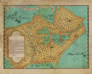
The original version of Joliet’s map was first published in the Jesuit Relations in 1674, and five contemporary copies were made. The map was the earliest to depict Mississippi based on first hand knowledge, and is one of the oldest maps of Canada made by a Canadian. The map depicts North America wholly surrounded by water, while the Great Lakes- Superior, Michigan, Huron, Erie and Ontario are presented as vast bodies of water in the interior. Did you know that Lake Michigan was called Lac des Illinois (Lake Illinois)? The lake became known as Lac des Illinois in 1679, a name derived from the Illinois Native American tribe that lived on its shore. The Great Lakes appear to be fed by two river systems, one being the Saint Laurent River, emptying into the Atlantic, and the Mississippi River(Riviere de Buade) that empties into the Gulf of Mexico.
This map indicates areas along the Mississippi River inhabited by various Native American tribes, including the Papikaha, Matora, Tanika, and other groups labeled as sauvages, such as the Tahensa and Apistonga. At the bottom of the map, the word Europeans is labeled, alongside drawings of crucifix, not only indicative of the presence of other foreign powers in North America such as the Spanish, but of their missionary undertakings as well. Places like Nouvelle, Quebec, Labrador and Florida are also clearly labeled.
This map was presented as a dedication to Louis de Buade, Comte de Frontenac et de Palluau, Governor General of New France. It served a purpose of establishing a trade route that playing an important part commercially and militarily for New France.
Purchase you copy here!
Educational Map Series: The lost map of Joliet
 See our maps of early discovery!
https://great-river-arts.myshopify.com/collections/antiquarian-collection https://great-river-arts.myshopify.com/products/educational-map-series-californias-first-appearance-on-a-map ; https://great-river-arts.myshopify.com/products/educational-map-series-the-lost-map-of-sir-francis-drake, https://great-river-arts.myshopify.com/products/educational-map-series-universalis-cosmographia-1507, https://great-river-arts.myshopify.com/products/educational-map-series-carte-de-lamerique-septentrionnale-1910 , https://great-river-arts.myshopify.com/products/educational-map-series-orteliuss-regionis-typus-1570 , https://great-river-arts.myshopify.com/products/nova-totius-terrarum-1605-hand-colored-laser-reproduction,
No comments yet.