
Baptista Boazio’s Irlandiæ c. 1606
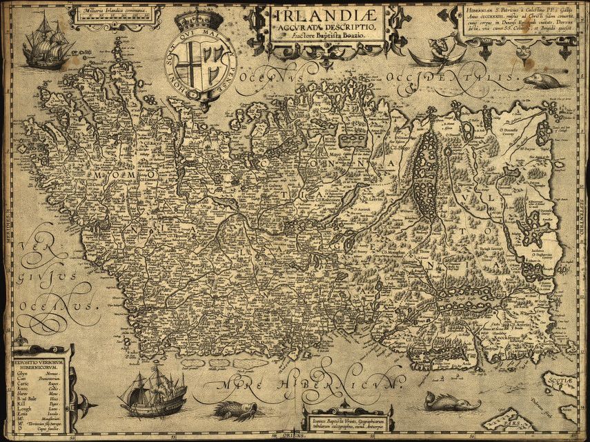 Some call it Irlandiæ accvrata descriptio and others say Irlandiæ accurata descriptio, but the map Baptista Boazio’s Irlandiæ c. 1606 = Irlandiæ accvrata descriptio is a magnificent work of art, science, and geographical knowledge combined. It was published in 1606 in Antwerp by Abraham Ortelius. This fine map of Ireland was produced by the reputed Italian cartographer Giovanni Baptista Boazio. What do we know of this 16th-century mapmaker? Giovanni Baptista Boazio called Britain home between 1585 and 1606. His works included drafting the route to America and the West Indies for Sir Francis Drake’s voyage, and creating a set of five maps that were published in the first printed Atlas of England and Wales by Christopher Saxton.
Other contributors to Boazio’s Irlandiæ accvrata descriptio include Jan Baptista Vrients(1552-1612) and Abraham Ortelius(1527-1598). Who was Jan Baptista Vrients and Abraham Ortelius? Vrients was a Flemish map engraver and publisher based in Antwerp during the 16th century. Ortelius was a Flemish cartographer who rose to prominence in the world of cartography in the 6th century. One of his most notable cartographic works is his 1598 Theatrum Orbis Terrarum (Theater of the World), published in Dublin. Ortelius is considered the creator of the first modern-day atlas.
A glance at this exuberant Irish map captures the sheer detail and beauty it displays. It has elements of a mappa mundi with medieval monsters in the sea at the top and bottom of the map. Their depiction tells of the unknown that early explorers of the time faced as they braved the vast expanses of water and ventured into unknown territories. Perhaps people of the Middle Ages believed in the existence of such strange monsters, they were simply conceptual ideas for added creativity. Who to tell? Carefully placed ships highlight European exploration that was taking place during the 1600s, perhaps amidst changes that were happening in Ireland at the time.
The map shows numerous Irish place names, some of which have different names today, and family names, which may have been the names of the major landowners in the region. A shift in land ownership took place in Ireland beginning in the 1600s and continued into the 1700s, from Catholic to Protestant hands, making it a place of great estates in general.
Also depicted is pictorial relief, a key in the lower-left region of the map which states: “Expositio Verborum Hibernicorum,” decorative cartouches and shield, topography, vegetation, ports, and waterways. The map is oriented with north towards the right, and there’s a historical note placed in the upper right area of the map. The purpose of the map may have been to create a source of reference to represent the political and religious shifts that took place in Ireland during that time.
No comments yet.