
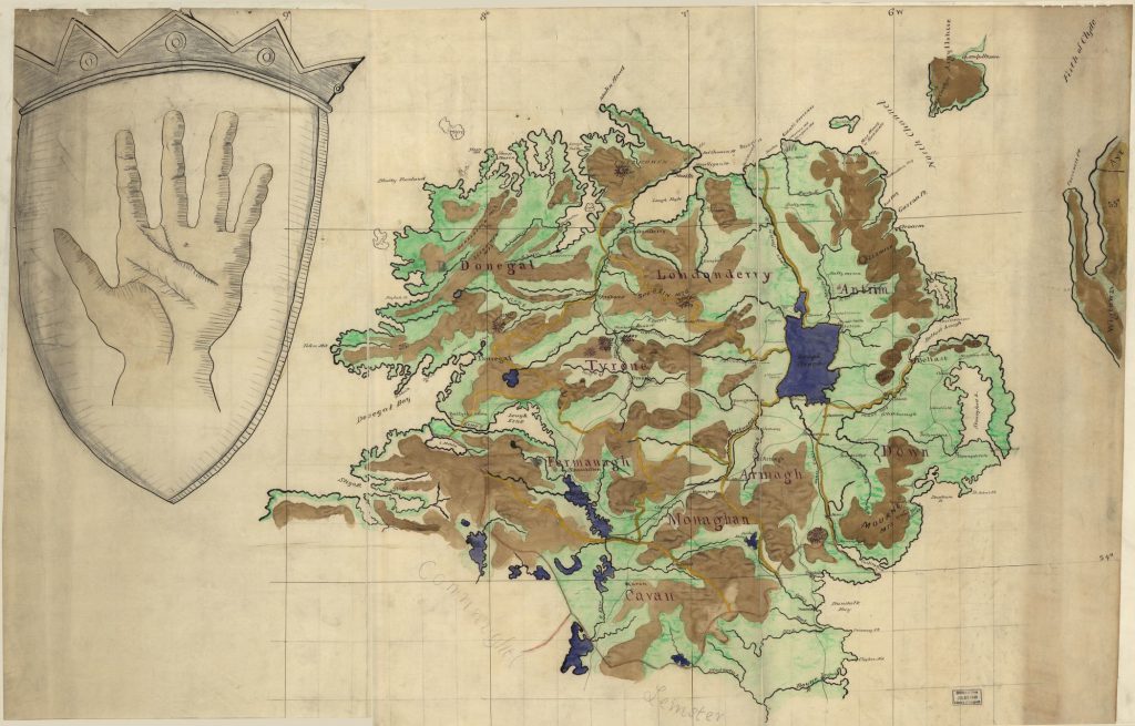
Map Of Ulster Province, Ireland
 Did you know that the “-ster” suffix comes from the Irish word “Stair” meaning province. Ulster is one of the four traditional provinces of Ireland. This ancient Irish province comprises nine counties, three of which make up the Republic of Ireland (Cavan, Monaghan, Donegal), and the other are in Northern Ireland (Antrim, Down, Armagh, Derry, Fermanagh, and Tyrone).
This map, titled, Map of Ulster Province, Ireland, was published in 1880 and shows the province as it was then, a time when Home Rule movement gathered force in Ireland. 18th Century Ulster had two elite classes, one predominantly Protestant, English influential landowners, and the other commercial Scots and English and were Protestants of various sects. Wondering which religious tradition was dominant among the Protestants in Ulster? It was Calvinism- the theological system of John Calvin that emphasizes salvation is only possible through the grace of God and that God is sovereign-above all else.
The economic divide in Ulster left some, like the Scotch-Irish, unhappy with the limited economic opportunity available to them. Discontent saw the Home Rule Movement embraced by William Ewart Gladstone, the leader of Britain’s Liberal Party, who helped to rekindle the anti-Catholic and anti-Irish sentiments that had already existed and pushed by the militant Protestant organization, Orange Order. The Orange influence was strongest in Ulster although it existed in other parts of the world. The crest/coat of arms in the upper left portion of the map, depicting an open large left hand, leaves one to wonder if it’s intended to represent the Red Hand of Ulster, an Irish symbol used to denote the province of Ulster. The exact origin and meaning of the Red Hand are unknown, but it’s associated with the Protestant community.
The counties of Ulster are depicted, along with major rivers, including Bush, Main, Lagan,
Blackwater, Foyle, and Dere rivers, among others. Mourne Mountains, Sper-rin Mountains, Slieve Mountains, and some heights were noted, as well as bodies of water, like Lough Neagh, a large freshwater lake, which touches five of the Province’s six counties’ shore. Some refer to Lough Neagh as Ulster’s inland sea and it is well known for its treacherous waters. Lough Neagh, which is nine miles wide and 13 miles long, contains dangerous sand holes, gets rough quickly, has varying depths, and swells that can climb to 9 feet high.
The purpose of this map may have been for political reference at a time when there were class and religious divisions, and rising tension growing conflict between supporters of Home Rule and those of the union. It could have been used to identify the counties that were predominantly planter class, Protestants, Catholics, or Scots. Today, the name Ulster is now commonly used to refer to Northern Ireland.
No comments yet.