
Discovery Map Series: Old Alaska Collection
In March of 1867, the United States purchase Alaska from Russia, expanding U.S. territory in the north. Only a small number of non-natives settled in Alaska in the decade after the purchase, however, that changed with the 1896 Klondike Gold Rush. Alaska was a vast wilderness, but eventually its tourism potential was realized.
With those seeking fortune or adventure, Alaska presented the opportunity for railroad companies to meet the new demands. These four maps of Alaska, which includes The Route of the Alaska Excursion Steamers, Millroy’s Map of Alaska and the Klondyke Gold Fields, The Alaska Line and Rand, McNally & Co.’s Alaska were useful guides for anyone venturing into Alaska in the 1900s, particularly persons who needed to have some knowledge of rail transportation routes for tourist adventure as well as gold prospecting.
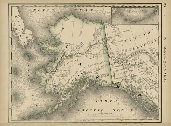
The Route of the Alaska Excursion Steamers map by Charles S. Fee’s shows the routes of the Alaskan Steams from U.S. and Canadian cities to different locations in Alaska on the Northern Pacific Railroad. The Rand, McNally & Co.’s Alaska map was published in Chicago 1878 by Rand, McNally and Company and shows a detailed mapping of the Alaska territory, featuring the Demarcation Point, which establishes the boundary between British and the former Russian territory. Millroy’s Map of Alaska and the Klondyke Gold Fields was published in 1897 and highlights the location of gold fields, along with practical information on the expected condition of the Alaskan environment, the climate and weather, warnings on a range of diseases, among other important information for anyone traveling to the Yukon region, especially gold prospectors. The Alaska Line was created by Edward Camy for the Alaska Steamship Company and is a cartoon representation of the services offered by the Alaska Line, along with the most interesting features in the region.
These maps as a whole were useful resources that served a primary purpose of promoting the rail lines that made it possible to reach the Alaska territory. While each map offered a different point of view of the Alaska territory and transportation, rail lines are primarily the main focus. They provide an element of social history, as well as cartographic history. Evident in these maps is a glimpse of the history of Alaska and the railroad system and to a larger extent, the history of the U.S. as it relates to its acquisition of Alaska and the development of early American railroads.
You can study and order the maps individually by following these links:
https://great-river-arts.myshopify.com/products/educational-map-series-rand-mcnally-co-s-alaska-1878
https://great-river-arts.myshopify.com/products/educational-map-series-the-alaska-line
For more of our Alaska Maps! Click Here
No comments yet.