
Discovery Map Series: The Route of the Alaska Excursion Steamers
Charles S. Fee’s 1891 map, titled “The Route of the Alaska Excursion Steamers” shows the routes of the Alaskan Steams from cities in the U.S and Canada to different locations in Alaska. These excursion steamers traveled on the Northern Pacific Railroad and leased lines. Charles S. Fee began his railroad career in 1873 as general secretary to the manager of the Michigan Central Railway. In 1877 he became H. E. Sargent’s secretary at the 400-mile Northern Pacific Railroad, and was later promoted to Northern Pacific General Passenger and Ticket Agent in 1885. He worked in the railroad business up until his death in 1923. The Northern Pacific Railroad was chartered by Congress in 1864 and was completed in 1883 in spite of financial troubles and Indian resistance.
The Route of the Alaska Excursion Steamers was published roughly five years before the start of Alaska’s Gold Rush period, and by then, several private rail interests came on the scene to meet the demands of prospecting migrants who wanted to make the move to Alaska. The Alaska Purchase in 1867 gave Americans the new northern territory, and it was the Klondike Gold Rush of 1898 that changed perceptions of Alaska’s value. Transcontinental railroads not only helped to bring gold prospectors to Alaska, but also tourist fascinated by the wildlife and scenery of the Alaskan wilderness. The railroads and waterways played a key role in facilitating movement into the northern territory.
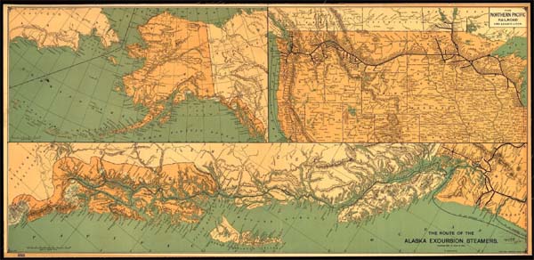
While Fee’s map references the route of the Alaska excursion steamers, the map actually depicts the train and ocean liner routes that many travelers likely took to make the journey to Alaska. The map features three different panels, with the upper left-hand panel showing the entire State of Alaska, the upper-right showing the Northern Pacific Railroad connections to Seattle from Chicago, along with connections down the coast into California and also included several stations along the route. The lower panel shows the Pacific Coast from Seattle, which took the inland waterway east of Vancouver Island to the steamer excursion routes on to Alaska through a chain of islands, including Admiralty Island, Chichagoff Island, Vancouver Island and Prince of Wales Island. Different destination points in Alaska included Juneau, Sitka, Chilcat, Fort Tongas and Fort Rangell. There are also connecting points from Canadian cities in Manitoba, like Brandon, Portage la Prairie and Winnipeg.
The purpose of this map was to promote the North Pacific Railroad and make the public aware of the opportunity available to reach Alaska via water and land through connecting transportation modes.
For more of our Alaska Maps! Click Here
No comments yet.