
Ortelius Improved Or New Map Of Ireland
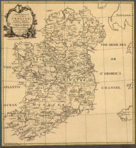 Ortelius Improved, or a New Map of Ireland: Wherin are Inserted the Principal Families of Irish and English Extraction, Who Possess’d that Kingdon on the Commencement of the Seventeenth Century is the 1795 historic work of Abraham Ortelius, who was a dominant 16th-century cartographer of Flemish descent. He is best known, perhaps, for his remarkable work, Theatrum Orbis Terrarum (Theater of the World), published in 1598 in Dublin. He is given credit as the creator of the first modern-day atlas. This map wasn’t complete without the touch of engraver S. Thompson.
Ortelius Improved, or a New Map of Ireland is a historic reprint that offers a depiction of the county boundaries and settlements within Ireland as they were in 1795. The location of numerous small settlements is mapped and some may no longer be in existence or have been given different names. Provinces such as Ulster, Connaught, Leinster, and Munster are highlighted.
Did you know that Connaught has a new spelling today? It’s was changed from its original spelling to C-o-n-n-a-c-h-t. It’s located in the west of Ireland and was home to several major Gaelic kingdoms up until the 9th century, including Lúighne, Uí Maine, and Iar Connacht. The name is derived from the medieval ruling dynasty, the Connacht, later Connachta, meaning “descendants of Conn”, associated with the mythical king, Conn of the Hundred Battles.
This unique Map of Ireland “Ortelius Improved, or a new map of Ireland” names principal families who owned property in Ireland at the commencement of the 17th Century. During that period, Ireland experienced successive transfers of land from Catholic ownership to English Protestant ownership. Still, some lands were also transferred to families with robust personal and material connections with England. Change in land ownership occurred mainly in the Province of Ulster but extended to other regions in the east of Ireland as well.
The purpose of this map may have been to produce a political instrument that could depict the shift in land ownership in Ireland at the start of the 17th century. It could have served as a source of reference that hadn’t existed before and was needed to perhaps disputes or even help to shape political discourse. All in all, this historic map of Ireland is detailed in its representation of a place in a specific time period, and it also shows the advancement that cartographers had made in mapmaking. It showed a new and improved Ireland of 1795.
No comments yet.