Mapmaking or cartography has been a part of our world’s history since ancient times. In truth, many specialists agree that map making had its beginning with cave paintings. However, the oldest known maps are carved on Babylonian clay tablets dating to about 2300 B.C. These maps were considered extremely advanced in Old World Greece.
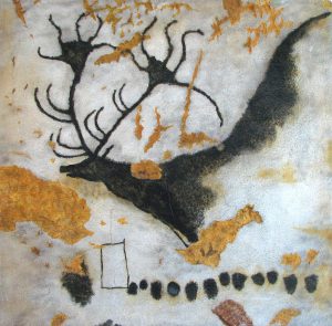
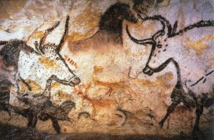
In addition, maps of the stars and not of Earth date back to 16,500 BC. These dotted constellation maps can be found on the walls of Lascaux (France). The maps include the Pleiades star cluster and the Summer Triangle asterism of three bright stars – Altair, Vega and Deneb.
Now cartography didn’t get its name until the 1840s. The term was presented in English from the French term cartographie, which is based on Middle Latin carta “map”. However, the ideal of a spherical Earth was renowned among Greek philosophers by 350 B.C. (Aristotle’s time). As well, the spherical Earth concept has been accepted by all geographers since then.
Early Cartography
The climax of Greek and Roman cartography was attained with Claudius Ptolemaeus (Latin) . Ptolemy or Ptolemaeus was an influential Greek astronomer, mathematician and geographer from around A.D. 85-165. In fact, his Old World map consisted from around 60°N to 30°S latitudes. Ptolemy also wrote colossal work, Guide to Geography (Geographike hyphygesis). This reference remained in authority until the Renaissance period (early 15th century).
Famous Maps
Throughout time, there have been numerous renowned maps that have made a huge imprint in history. Quite frankly, some maps tell a story of their own and are quite intriguing. For instance, ancient Chinese maps have many legends. One of these legends is called He Bo Xian Tu (河伯獻圖), basically meaning “the River Deity presenting a map”. Legends states that during the fabled Xia dynasty, a river spirit gave Yu the Great (famed for flood control) a flood map that was etched on the surface of a large stone. Yu the Great used the map to help tame the flood threatening to devastate rural agriculture.
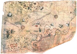
Piri Reis map
This world map made its debut in 1513 from military intelligence by an Ottoman (Turkish) cartographer and admiral Piri Reis. The surviving 1/3 fragment of the map shows the western shores of Europe and North Africa plus the coast of Brazil. In addition, the map includes the Canary Islands and the Azores and portrays them as being located in the phantom island of Antilla (possibly Japan).
What is fascinating is that the map is drawn on gazelle (antelope) skin parchment. It was discovered in 1929 by German theologian Gustav Adolf Deissmann while cataloging the Topkapı Palace library’s non-Islamic items. Crazily, Deissmann found them in a discarded bundle. The map is a portolan chart -four compass roses (two large and two small) where the lines of bearing radiate.
The Piri Reis map is of great importance because it was the only copy of Christopher Columbus‘s (1451–1506) world map. It was also the only map that displayed South America in the proper longitudinal position relating to Africa. In fact, many experts agree that this may be the a “lost map of Columbus”.
Mappa Mundi
Mappa mundi is in reference to any medieval European map of the world. The word Mappa mundi is Medieval Latin meaning mappa (cloth or chart) and mundi (of the world).
There were a large variety of medieval maps ranging from small and simple maps 1 inch (25 millimetres) in size to rather large maps that covered an entire wall. The largest known Mappa mundi measures 11 x 6 in diameter (3.5 m).
There are around 1,100 mappae mundi that survived the Middle Ages. About 900 of these maps can be seen as stand-alone documents or found as illustrations in manuscripts.
Additionally, many of medieval maps were dominated by religious views. The T and O map was quite common. This format uses Jerusalem at the center. Also, east is oriented toward the map top. Around the 12th century, Viking explorations in the North Atlantic were slowly integrated into world view maps. But it was during this time that more real-world and accurate lines were used in cartography, including the Arabic lands and Mediterranean region. Of course, most maps were drawn and illustrated by hand. This made the distribution of maps very limited and difficult.
Modern Day Authentic Maps
Through the years, maps have become increasingly accurate. Today’s maps are mostly GPS and digital in nature. However, the GPS format has lost the ancient format of history and the ambiance of art. And as with most cultures, were strive to surround ourselves with things of beauty and meaning.
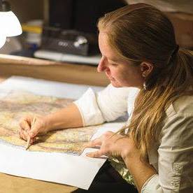
And just like the hand painted maps of yesteryear, you can own you very own Mappa Mundi. Fortuitously, gifted artisans like Lisa Middleton have the passion and expertise to restore ancient maps with lively or neutral colors of eloquent detail. And like the Mappa Mundi maps, Lisa’s hands painted historical maps contain the magic of enchantment and history.
Some of Lisa’s collection includes Eastern Maps, anAntiquarian Collection, Children’s Maps and more:

No comments yet.